Maps are
tricky things for historians. We used to use them for a long time. They are marvelous
for putting complex issues in one single picture, to illustrate and to convince
of our arguments. They help us to set the backstage of our stories (and
therefore we often tend to neglect it). But maps are problematic, too. It is its
supposed simplicity of representation, its abstract pureness that evokes and promises
to us objectivity. The abstractness and simplicity of maps results in an
opaqueness that veils the process of its making.
 |
| Map of the Bahr el Ghasal region according to Wilhelm Junker, compiled by Hassenstein |
One major illusion
about maps is that they are representing something like a fixed essence or state
of knowledge. They do not. Map-making in the 19
th century was a very
arduous, complicated and multi-layered
project, which included a lot of people starting from travelers like Henry
Morton Stanley and their entourage of their Europeans fellows and African
companions to the editors of the travel accounts, the cartographers, drawers,
mathematicians, translators as well as
print workers, lithographers and experts for color mixing. The knowledge of
maps underwent a long way from the pages of the traveler’s sketchbook to the
printed map. On each stage, different ways of producing and representing
knowledge came into play. Different actors with different horizons of knowledge
and agendas selected, edited and redraw what would be shown on the map and how.
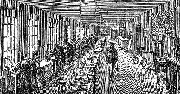 |
| The production of maps in the Carthographic institute at Gotha |
Most
travelers of the 19th century were rather new to the practice of
cartography. At best, they got some initial knowledge during their service in
the military. This initial training was indeed a reason why active or former officers
were prominent among 19th century explorers. Nevertheless,
cartography itself was a technology of representation that underwent dramatic changes
during the 18th and 19th century.
 |
| Map of Africa by Ptolomeus (150 a.d.) |
Maps, once been
inhabited by mythical creatures like two-headed animals or tailed humans,
increasingly became a place for scientific codes and representations.
Astronomy, mathematics, geography, history and ethnography became the main
means to built the encyclopedic design of maps. The invention or improvement of
measuring devices like thermometers, sextants, or theodolits and the
introduction of new ways of measuring like triangulation radically changed the
practice of cartography in the 19th century.
 |
| Instruments for carthographs in the 18th century |
Cartographers and travelers,
therefore, were bound in constant process of learning. Handbooks for scientific
practice and traveling helped the travelers to keep up with the newest
requirements of cartography. Many things, nevertheless, were simply learning by
doing.
 |
| Sketches of routes by Wilhelm Junker (in the Bahr-El-Ghasal-Region) |
Still at
the end of the 19th century, counting steps was an important way to
measure distances. It was an laborious and self-disciplining exercise for many
travelers, who faced not only inhabitable and scarcely developed regions, but
also shortages of food, illnesses and many conflicts with the local population.
The first products of this measurement were logbooks with the distances the
explorers overcame on a day. From these logbooks they draw sketches of their
routes – first map that looked very abstract. This was often done while being
at a night camp.
 |
| Sketch of Junkers routes in the Bahr el Ghasal region |
The representation of the travel though an abstract space contradicts with what the travelers produced as an image in their travel accounts, where Africa still was inhabited by all sorts of monsters, dangers and exotic creatures.
 |
| Scenes from Stanleys books about his travels through Africa |


Comments
Post a Comment